Snapshot
Fondaway Canyon is an advanced stage gold property located in the Churchill County, Nevada. The land package contains 136 unpatented lode claims. The property has a history of previous surface exploration and mining in the late 1980’s and early 1990’s.
On April 11, 2017 Canarc completed an updated, independent, NI 43-101 resource estimate for the Fondaway Canyon property.
Techbase International of Reno, Nevada completed the technical Report for the Fondaway Canyon Project. The updated resource estimate included in the technical report is shown in the table below.
| Resource Category |
Tonnes1 (t) |
Grade (g/t) Au |
Ounces2 (oz) Au |
Type |
| Indicated | 2,050,000 | 6.18 | 409,000 | UG/Sulfide |
| Inferred | 3,200,000 | 6.40 | 660,000 | UG/Sulfide |
| 1 Resource based on cut-off of 1.8m horizontal width >= 3.43 g/t 2 Rounding differences may occur |
||||
- CIM Definition Standards were followed for reporting the Mineral Resource estimates
- Mineral Resources are reported on a dry, in-situ basis. A bulk density of 2.56 tonnes/m3 was applied for volume to tonnes conversion.
- The reporting cutoff grade of 3.43 g/t was based on capital and operating costs for a similar project, the three-year trailing average Au price of $US 1,225/ oz Au , a metallurgical recovery of 90%, and an underground mining method suitable for steeply-dipping veins.
- Mineral Resources are estimated from surface to approximately 400 m depth.
- The quantity and grade of Inferred Resources in this estimate are uncertain in nature, there has been insufficient exploration to define these Inferred Resources as an Indicated or Measured Mineral Resource and it is uncertain if further exploration will result in upgrading them to an Indicated or Measured Mineral Resource category. Environmental, geotechnical, permitting, legal, title, taxation, socio‐political, marketing or other relevant issues could materially affect the mineral resource estimate.
The Resource Estimate was prepared by Michael Norred, SME Registered Member 2384950; President of Techbase International, Ltd (Techbase) of Reno, Nevada and Simon Henderson, MSc, MAusIMM CP 110883 (Geology); Consulting Geologist with Wairaka Rock Services Limited of Wellington, New Zealand, both Qualified Persons (QPs), as defined by NI 43-101.
The Fondaway Canyon mineralization is contained in a series of 12 steeply dipping, en-echelon quartz-sulfide vein-shear zones outcropping at surface and extending laterally over 1200m and vertically to depths of > 400m. The Paperweight, Half-moon and Colorado zones host the bulk of the resources, with the remainder in parallel veins or splays of the major vein-shears.
A total of 591 historic drill holes were validated for resource estimation, with coordinate information and down hole assays. These included 8411m of core drilling in 49 holes and 40,675m of RC drilling in 551 holes. Drill core was inspected at the Fallon, NV storage facility and assay certificates were viewed to verify gold intercept grades used in the estimate.
Check assays were run systematically on approximately 5% of the total assays, including 23% of assays greater than 3.43 g/t. Duplicate assays were run on slightly less than 1% of the total assays, including 14% of assays greater than 3.43 g/t. Consistency was good for the check assays and duplicates, with correlations greater than 98% in each case.
A Mineral Resource was estimated for each vein using polygonal estimation on drill intercepts projected onto a vertical long-section parallel to the average strike direction of that vein. The polygons were truncated at faults that were interpreted to limit the extent of the mineralization.
The Mineral Resources are reported at a cut-off of 3.43 g/t, over a minimum horizontal width of 1.8m, based on projects of similar size, a gold price of $US 1,225 per oz, a metallurgical recovery of 90%, and an underground mining method suitable for steeply-dipping veins. A processing method has not yet been selected.
Metallurgical testing showed that acceptable recoveries could be obtained from the sulfide material by using an oxidizing pre-treatment, followed by CIL leaching, with recoveries up to 86 to 95%. Further metallurgical testing and design work will be needed in order to design the most cost-effective method
No capping or cutting of grades was applied. The assayed grades were found to be very consistent when compared to check assays and duplicates, as well as between twinned holes. The consistency in assay results was interpreted as being due to the very fine-grained nature of the gold mineralization (1 to 10 µm). This consistency provided confidence that the higher-grade assays were reasonable.
Figure 1 shows the location by zone of the Fondaway Canyon resources.
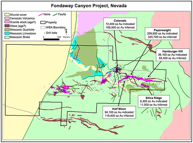
The current Mineral Resource estimate relates only to the eastern half of the 4000m east-west striking mineralized system, and does not include any estimates for near-surface, oxide mineralization. Significant exploration potential remains both in the eastern section, and relatively untested western zone.
Multiple exploration targets have been identified along favorable structural extensions that have potential to host additional significant gold resources. A 30-hole drill program, estimated to cost $2.0 million, has been recommended by Techbase International to explore these identified targets as well upgrade more of the resources into the indicated category.
Dixie Comstock, also located in the Churchill County, Nevada, consists of 26 unpatented lode claims. It also has evidence of some historic mining but no records of production are available.
A historic 1991 geologic and mining study completed by Mine Development Associates of Reno, Nevada, in March 1991 estimated a geologic resource containing 146,000 ounces of gold in 4.26 million tonnes grading 1.063 g/t Au at a cut-off grade of 0.34 g/t Au.
This resource is a historic estimate and a qualified person for Canarc has not done sufficient work to classify the historic estimate as a current mineral resource. As a result the historic estimate is not being treated as a current mineral resource.
Clear Trunk property is located in Pershing and Humboldt Counties, Nevada on 4500 acres of fee mineral and unpatented claims in the Sonoma Range, south of Winnemucca.
The property contains a small discovery of a sediment-hosted disseminated gold deposit from 40 drill holes. Intercepts included: Hole CLO4-5 = 26m at 0.38 g/t Au and 81m at 0.45g/t Au, Hole CLO4 -16 = 119m at 0.34 g/t Au, Hole CLO4-19 = 29m at 1.06 g/t Au and 11m at 1.13 g/t Au.
Identified exploration target include breccia pipes and quartz stockwork with untested gold anomalies and untested soil gold anomaly overlying intrusive host rock.
Bull Run property is located in Elko County, Nevada on two large patented claim groups of 500 acres near Jerritt Canyon.
Historic mining at the Bull Run mine developed 1 to 2 m wide quartz veins with 17 g/t Au before it closed in 1901.
A large quartz silver-gold vein system has been identified over a mile in length, 12 m wide, with silver grades from surface samples up to 685 g/t and up to 5.1 g/t gold.
Future exploration work has the potential for new gold and silver bonanza-grade discoveries.
Hot Springs Point property is located in Eureka County, Nevada on 160 acres of fee land on north end of the prolific Cortez Trend. Klondex Mining claims surround the project on three sides.
The property contains mafic dikes and sills with gold up to 3.4 g/t. Three shallow holes at north end of the property intercepted up to 1 g/t Au.
Jarbidge property is located in Elko County, Nevada on 8 patented claims along the east end of major gold veins in the Jarbidge mining district.
Veins that have historically produced over 400,000 ounces of gold strike directly onto the property and gold soil anomalies identified on the property need to be drill tested.
Lightning Tree property is located in Lemhi County, Idaho on 11 unpatented claims near the 300,000 oz gold Musgrove deposit.
The property has 3 quartz-adularia-gold veins that are 2 to 6 m wide and over 1200 m long hosted in Precambrian siltstone and rhyolite with historic surface samples up to 21 g/t Au.
Silver King property is located in Humboldt County, Nevada on 4 patented claims near Golconda Summit.
Historic samples have been collected from jasperoid veins with Silver values up to 480 g/t.
Previous exploration focused on low grade gold values but the property was never been explored for silver.
A&T property is located in Humboldt Co., Nevada on 2 patented claims on Winnemucca Mountain.
The property contains two veins and a quartz breccia in altered shale adjacent to intrusive dikes. Gold values grading up to 8.6 g/t have been collected in historic surface sampling of quartz veins.
Eimis property is located in Elko County, Nevada on one 20 acre patented claim adjacent to a new Coleman Canyon gold discovery by Arnevut Resources. Gold anomalies extend onto Eimis property.
Silver Peak property is located in Esmeralda County, Nevada on 2 patented (40 acre) mining claims. The property is surrounded by Scorpio Gold claim block at the currently operating Mineral Ridge mine.
Historic surface sampling has yielded 1-5 g/t gold from 1.5 to 9 m wide east-dipping shear zone in metamorphic rocks, similar to Mineral Ridge.