|
||||||||||||||||
|
|

|
||||
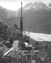
New PolarisIntroduction A small, high grade, underground past producing gold mine, New Polaris has become one of the largest gold deposits in western Canada as a result of Canarc’s successful exploration programs. The geological resource estimate is currently 1.3 million oz. at US $325 gold, but the mineralization is wide open along strike and at depth and could easily double with further drilling. New Polaris is currently on the “back burner” until gold prices improve and the neighbouring Tulsequah Chief base metal mine project commences construction of an access road which would make New Polaris much more attractive economically Location and Access Northwestern
British Columbia, 60 miles south of Atlin, B.C., and 40 miles east of
Juneau, Alaska, on the west bank of the Tulsequah River near the B.C.-Alaska
border. Access is provided by small aircraft from Atlin or Juneau but
ocean barging of equipment and supplies to the minesite is possible. Description and Ownership Sixty-one crown granted mineral claims and 1 modified grid claim totaling 2,956 acres, 100% owned by Canarc subject to a 15% net profits interest to Rembrandt Gold Mines, which Canarc can reduce to 10% NPI. Current Status Currently on hold pending higher gold prices and the construction of the Tulsequah Chief access road, both of which will have a dramatic positive impact on the project economies. New Polaris is an advanced stage exploration project, requiring infill drilling to further define proven and probable ore reserves followed by a full feasibility study. Mining History Discovered by prospectors in 1929, the mine was constructed in 1936 and operated from 1937 to 1942 and again from 1946 to 1951. A total of 232,000 oz. gold was produced from 760,000 tons ore grading 0.35 oz./ton. Flotation concentrates were shipped seasonally for refining to the smelter in Tacoma, Washington. The first barge load in 1951 sank in a storm off the B.C. Coast, causing the mine to shut down. Cominco upgraded the mill in 1952 and used it to process their nearby Tulsequah Chief ores from 1953 to 1957. New Polaris was then dormant for 30 years until exploration resumed in 1988. Canarc acquired New Polaris in 1992, completed 135,000 feet of core drilling in 182 drill holes and discovered major new ore zones below and beyond the mine workings. Deposit Potential Three million ounces plus, similar geologically to Placer Dome’s Campbell Red Lake Mine (10 million oz.) high grade refractory ore body. Canarc’s goal is to create sufficient reserves to allow development of 1,000 ton per day mine, producing over 120,000 ounces of gold per year. Mineralization associated with disseminated arsenopyrite, pyrite, and stibnite in quartz carbonate veins and stockworks, and related carbonatized and sericitized alteration zones. Zones developed along principal shear sets adjacent to a major crustal break. Host rocks are Paleozoic volcanics. Gold mineralization is late Cretaceous to early Tertiary and epithermal or mesothermal shear vein type. Gold is occluded in finely disseminated arsenopyrite grains that permeate
the altered wall rocks and vein stockworks. Lesser pyrite, stibnite, and
rare sphalerite occur within an alteration assemblage of quartz, carbonate,
sericite, fuchsite, and albite, composing the gangue mineralogy. Gold
mineralization occurs along three major shear sets: AB zones - trending
northwest/southeast, Y zones - trending north/south, and C zones
- trending east/west. C zones generally link with the AB and with
the Y zones at “junction arcs”. Gold values in stockworks
show excellent continuity and uniformity, with very little nugget effect.
Individual zones pinch, swell, and overlap en echelon. Individual ore
blocks range from less than 1,000 tons to more than 100,000 tons in size.
Widths range from 1 to 45 feet in thickness, averaging about 10 feet. Resources Current resources estimated at 3.6 million tons at a grade of 0.36 ounce per ton gold (1.3 million ounces). Detailed modeling is currently underway using GEMCOM software. Mining From 1931 to 1951, 51,825 feet of level development (on 10 levels) and 12,292 feet raise development were completed at New Polaris. Top level, Canyon, is 580 feet above sea level. Deepest level, 750, is 613 feet below sea level. An 821 foot internal winze used for material handling, going from the A.J. to the 750 Level. Winze is accessed from the A.J. and Polaris Level adits, with Polaris being the main haulage and access level. Mine dewatered in 1996, ground conditions excellent. Historic mining methods were shrinkage and resuing. Plans are to develop a ramp access mine. Mining methods will include longhole, shrinkage, cut-and-fill. Mining techniques will depend on factors such as ore body geometry, grade, dilution, etc.
Metallurgy Historically, the mine operated using sulphide flotation, milling at a rate of 200 tons per day. Ore crushed through primary and secondary crushers, and ground in a ball mill in closed circuit with a rake classifier. Rougher and scavenger flotation used and the sulphide concentrate thickened and filtered for shipment off site. Ninety percent gold recovery, concentrate grade of 3.5-5.0 ounce per ton gold, and concentrate to ore ratio of 10-15:1. Recent test work completed on a preliminary basis. Using flotation, cyanidation of the flotation tailings, and pressure oxidation (autoclaving) of the flotation concentrate, 94 percent gold recovery achieved. Additional metallurgical test work is planned to optimize grind, reagent addition and type, etc. Evaluation of direct marketing of the flotation concentrate, pressure oxidation, bio-oxidation, and microwave processes to treat the flotation concentrate will be completed in future work. Site Infrastructure New office/dry complex built on the site. Several existing buildings refurbished for bunkhouses and a kitchen facility. Existing camp capable of supporting 35 personnel. Shop refurbished for a maintenance facility, pipe shop, power house, and compressor house. Three 200 kilowatt generators on site that can be run separately or in parallel. Two 200 cubic feet per minute portable air compressors on site to supply compressed air for underground. Two 10,000 gallon fuel tanks, left from previous mining activities refurbished for additional fuel storage. Old main street of the town site used as an air strip. Manpower, equipment, and material mobilized to site using a Shorts Skyvan, capable of carrying 4,000 pounds. Environmental Canarc has been systematically eliminating all old mine buildings at the site, except those in current use. Test work indicates rock is non acid generating. Water wells installed and surface and ground water monitoring underway. Discharge permit obtained for the dewatering and care and maintenance phases of the mine pumping. Production Model Base case 90,000 oz./year for 8 years at 750 tons/day, with potential to expand to 1,000 tons/day or 120,000 oz./year, capital costs estimate US $50 million, operating costs estimate US $180 to $240 per oz., Canarc is currently investigating a more aggressive development plan to transport New Polaris ores to an offsite mill facility in order to reduce capital costs and enhance project economies.
|
|
|||
disclaimer |
||||